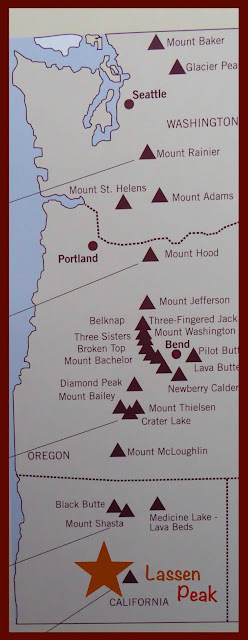
Carol writes: For the past month our travels have followed a significant section of the 500-mile Volcanic Legacy Scenic Byway as it meanders south along the volcanic peaks of the Cascades. As summer faded into fall, we were treated with autumn’s brilliant display of color on trees along our route.
Lassen Volcanic National Park marked the southern boundary of the California section of the scenic byway through the Cascades. Nature persisted in showcasing the best side of autumn’s ritual at our first clear view of snowy Lassen Peak.
This national park was clearly a hiker’s dream, with 150 miles of park trails that included 17 miles of the Pacific Crest Trail.
Benjamin Franklin Loomis and his wife, Estella, were turn-of-the-century settlers in the Lassen area. In June 1914 national fame descended on Benjamin Loomis when he captured the eruption of Lassen Peak in a series of thrilling photographic shots.
The start of the explosion in frame #2 was particularly dramatic. The vintage automobile in the foreground added to the excitement of how perfectly Loomis captured this historic event.
The 30-mile-long highway through the park offered great access to many of the park’s major features, such as…
- the Chaos Jumbles, a giant boulder debris field that was created 300 years ago when, for unknown reasons, a massive rock avalanche slid from the domes of the Chaos Crags.
- the trailhead to the summit of Lassen Peak. One of the climbers that had come down told us that she turned back when she came to a treacherous icy snowfield just short of the summit. She was a girl of obvious Asian descent with a very slight accent. When I asked her where she was from, she replied, “Hanoi, Vietnam,” then told us a bit about how her life led her to California. Similar unexpected stranger encounters have turned out to be a fundamental part of the simple joy of life on the road.
We were able to get some zoom shots of hikers near the summit.
- brilliant blue Lake Helen nestled at the foot of Lassen Peak.
- a small area of bubbling hydrothermal activity, a reminder that the tranquil visible image of Lassen Volcanic National Park hides an extremely volatile subterranean world.
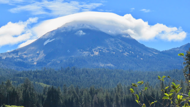
- unusual lenticular-type clouds that hovered over Lassen Peak during a walk around Manzanita Lake.
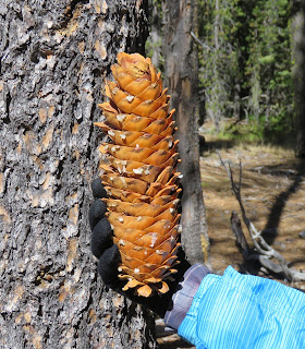
and finally, those incredibly long sugar pine cones, a discovery that we made on one of the park’s nature trails.
Lassen Volcanic National Park certainly lived up to its reputation as a wild wilderness with lots of opportunity to appreciate its violent volcanic history. I wished we had been able to stay another day, but near-freezing nighttime temperatures were signaling that winter was fast approaching and that we had better continue a sustained move south. And so we drove 125 miles south to:
JACKSON RANCHERIA
In 2000 the State of California passed an amendment that established the right to gaming on Native American tribal lands. A farsighted member of the Miwok Indian tribe named Margaret Dalton used this newly established right to gaming as a means for creating a life-altering, self-sufficient way of life for her people. And it seemed to have worked out pretty well for the Miwok…
Jackson Rancheria Casino Resort is located on Miwok tribal lands. We had been told more than once that Jackson Rancheria RV Park was one of the best campgrounds in the entire state of California, so we had very high expectations… and we were NOT disappointed.
The RV park was laid out to perfection atop a superb plateau on the outskirts of Jackson, CA. Amenities were first-rate. We even held our own for a few hours at the casino.
However, it was the nearby Chaw’se site at Indian Grinding Rock State Park that was of much more interest to us. For centuries, Chaw’se had been the ancestral home for the Northern Sierra Miwok. Chaw’se is the Miwok word for the “mortar cups” that were used for grinding acorns and other seed into meal. Over centuries of Miwok habitation at Chaw’se, more than a thousand of these grinding pits were carved into the limestone bedrock.
A short nature trail featured reconstructed examples of Miwok bark houses,
and a semi-subterranean ceremonial roundhouse.
At Chaw’se one could easily imagine the somewhat idyllic lifestyle that the Miwok once cherished in this small valley 2400 feet above sea level. The climate was ideal, and there was a multitude of food, medicine and materials for daily living. This Miwok treasured way of life all came crashing down when gold was discovered in 1848 at nearby Sutter’s Mill. After that, the California Gold Rush was on.
On the way home from Chaw’se we bushwhacked for an hour or so along backroads through the Sierra foothills to make a brief visit to Placerville, a former hub of 49er gold mining operations. Placerville was a typical western tourist town, and the gold rush history that played out in the streets was its chief attraction.
The common historical name for Placerville was “Hangtown,” for all the obvious reasons. The hanging dummy high above the Hangman’s Tree first got our attention, then so did the yummy ice cream for sale inside...
Next stop—Mono Lake, for another replay of memories from our last visit to Lee Vining during our 1989 family year on the road when we stayed at the very same campground! Several days of brilliantly blue skies were in the forecast, and snow seemed to be holding off for now in the high country. From our base camp in Lee Vining on the shore of Mono Lake, we are planning a revisit to our favorite ghost town, along with a little rock hunting on the side…


No comments:
Post a Comment