March 30, 2019

A WEEK ALONG THE INTERSTATE IN WILLCOX, AZ

Carol writes:  As we travel from campground to campground along our nation’s interstate highway system, we have noticed thousands of campgrounds that butt right up against the interstate.  Many times we have commented to each other, “Who stays in such noisy campgrounds?”

Well, that would be us!  We have joined the ‘noisy campground’ ranks, because in Willcox, Arizona, there really was no other good choice.  The Willcox-Cochise KOA was a neatly maintained, newly updated campground that was just about perfect in every way…


except for the grinding traffic noise of Interstate 10.  And, as “luck” would have it, our site was among the closest to I-10, bustling with all the semis rolling by…


As it turned out, the wind was howling so much when we arrived that we delayed extending our slides or raising our Direct TV satellite dish until early evening.  What traffic noise?  For the next few hours, the wind was so loud and we were so well insulated inside our cozy bus that any traffic noise was insignificant!

We soon discovered that although the old-town part of Willcox appeared “just a few heartbeats short of a ghost town,” for a  sandhill crane this was a pretty ideal place to spend the winter months.  The next day we headed over to a large marshy lake area surrounded by magnificent grasslands and the soaring mountain scenery of Dos Cabezas


It wasn’t long before we spotted— and heard—a large flock of sandhill cranes circling and swooping overhead after coming back from a morning of feeding in the mountains.

For the next hour, we were mesmerized by the landing behavior of this very large flock of noisy sandhill cranes.  In a most organized manner, small groups of birds peeled off from the main flock and slowly spiraled down to their chosen nesting spot for the night.


As each small flock of cranes got close to the landing zone, each member dropped long skinny legs, much like a human parachutist, and within seconds had landed.


Meanwhile, all bird behavior on the ground was amazingly calm and quiet.


There was a method to our madness for choosing a campground so close to the I-10 corridor, and that was for the opportunity to visit two national sites on our bucket list.

FORT BOWIE NATIONAL HISTORIC SITE

The story at Fort Bowie was closely tied to the Army’s efforts to subdue the hostile Chiricahua Apaches, led first by Cochise and then by Geronimo.  The other crucial mission of the soldiers at Fort Bowie was to protect the vital water supply at Apache Spring, which was positioned along the transport corridor known as Apache Pass, a key route for westward expansion in the mid-19th century.

The only way for today’s visitors to visit Fort Bowie was to hike a 1-1/2-mile trail through an historic valley in Apache Pass.


Along the way we passed the skeletal stone foundation of the Butterfield Stage Station, a stopping point on the old overland mail route.


A little further up the trail we came to the Fort Bowie cemetery.


Since most of the graves of Fort Bowie soldiers and their dependents have been relocated to a national cemetery, 23 civilian gravesites were all that remained at the post cemetery.  The gravesite of Geronimo’s 2-year-old son, Littlerobe, and very young Medal of Honor recipient O.O. Spence were most noteworthy.


We encountered a bit of a climb through a hilly canyon up to the grounds of the fort, but once we crested the hill, the strategic advantage of this relatively level site was apparent.


A few adobe-reinforced stone walls were all that remained of what was once a fully functional frontier Army fort.


It was interesting to compare our photograph of Fort Bowie to one that was taken on a quiet January day in 1894.


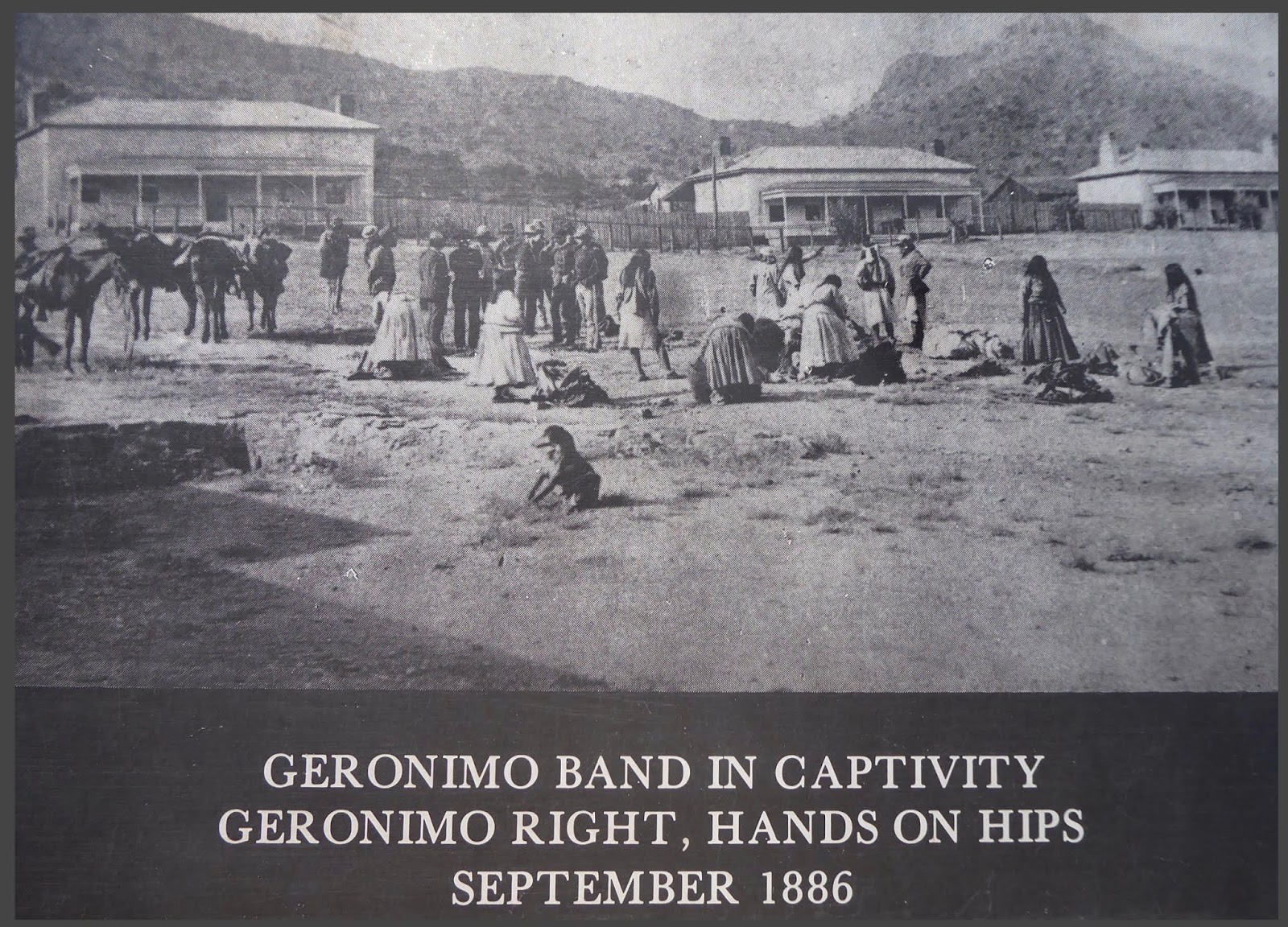
After final surrender in 1886, Geronimo and his followers were brought to Fort Bowie, then put on a train for the long and sad journey to exile in Florida.  I was most fascinated by an old photograph that depicted Geronimo in a casual moment on the parade grounds of Fort Bowie.  Geronimo was pictured to the right with hands on hips.


Shortly after Geronimo was captured, Fort Bowie closed.  Local ranchers salvaged lumber from vacant buildings for personal use, leaving history’s story to be told by the ghostly stone outlines of what was once a strategic frontier Army post.

CHIRICAHUA NATIONAL MONUMENT


Prior to Geronimo’s surrender in 1886, the grand rock pinnacles that tower over the valleys of Chiricahua National Monument were once home to the Chiricahua Apaches, who called  these rock formations The Land of Standing-up Rocks.


This wonderland of rocks has a volcanic origin dating back 27 million years.  Over many eons, uplift and erosion between the columns has created massive layered pinnacles of volcanic gray rock called rhyolite.


After Geronimo’s surrender, the story at Chiricahua continued at Faraway Ranch,


the peach and green adobe home of Swedish immigrants Neil and Emma Erickson.  Neil and Emma raised three children at the ranch.


The ranger-guided tour of the ranch house was a wonderful peek back to a time when the Erickson children used their much-loved homestead as a guest ranch.

The children and their spouses were very civic-minded and devoted much of their lives to fostering appreciation of the land they treasured.  Their dependents built trails throughout the park and lobbied our government for its protection.  
  
It was to those very trails that we turned in order to explore one of our nation's very special treasures.


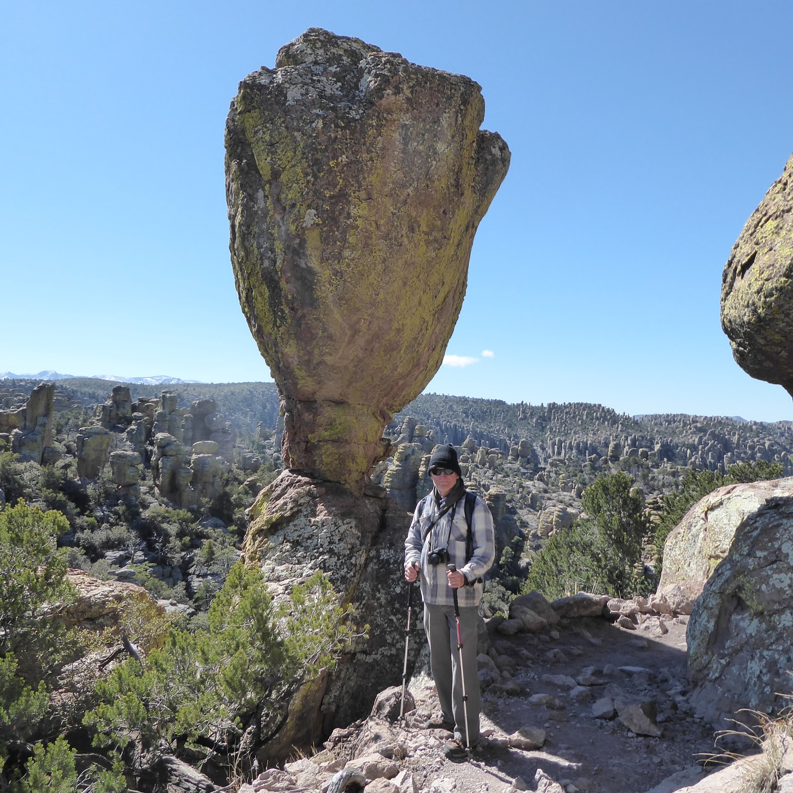
Monument literature stated that the 3.3-mile Echo Canyon Loop Trail is considered the premier trail of the monument.  As we headed into Echo Canyon, the trail wound through wondrous rock formations that were a photographer’s delight.


Giant boulders that seemed impossibly balanced were the ones that beckoned our camera shots.


The trail section through so-called “Wall Street” had natural vertical walls that almost looked man made.


A convenient stone bench served as a perfect lunch spot.


When we looked into the distance along Echo Canyon Trail, we got to thinking that one day of hiking didn’t seem sufficient at Chiricahua.  After we heard about an early-morning shuttle van that would transport us to the high point in the monument, thus enabling us to hike 7.3 miles “mostly” downhill along other scenic trails, we were convinced we needed another day.

After a van ride to the top, we had lots of energy for an early-morning start.


Almost no wind and warm sun created ideal hiking conditions.


Our plan was to get to the Heart of the Rocks Loop for a look at some of the most unusual rock formations in the monument.  This trail was difficult with lots of huge rock steps, but it was worth it to see the famous rock formation known as “Punch and Judy,” who have been shouting at each other for thousands of years.


The last section of the trail back to the Visitors Center was downhill through Rhyolite Canyon where, fittingly, we were surrounded by some of Chiricahua’s best wilderness scenery.


Well, that was a satisfying week camped along Interstate 10 in southeastern Arizona.  Time to head over the state border to Silver City, New Mexico, where our next campsite backed up to the city cemetery and promised lots of peace and quiet. 

Carol Galus
Photo-Blogger


March 16, 2019

IN THE STEPS OF CORONADO NEAR HUACHUCA CITY

Carol writes: Our next campground was in a remote location situated several miles outside of Huachuca City, Arizona.  


We trusted that our “temporary home” for the next two weeks would serve as an excellent basecamp for exploration of this corner of southeastern Arizona, an area notable for many centuries of rich history.  

THE SPANISH ERA


One of the best places to begin the story of exploration and settlement during the Spanish era was at the Coronado National Memorial, which was established to commemorate the first major European expedition into the Southwest.  


In the mid-16th century, under orders from the King of Spain, an expeditionary force of over 1000 led by Francisco Vasquez de Coronado marched through the San Pedro River Valley into present-day Arizona.  


The expedition was tasked with searching for the Seven Cities of Cibola and its fabled gold.

From the parking area at Montezuma Pass, the route of Coronado’s expedition could clearly be appreciated in the distance.  


Within sight of the Mexican border at the summit of the Coronado Peak Trail, natural panoramic views of two nations were stunning. 


The border wall stretched into the distance as far as the eye could see, as sharply defined as a line drawn on a map.


Explorers from Spain came to this frontier area with plans to convert the indigenous population to Christianity.  In the process, Native American lands were seized and secured for the Spanish crown.  Such was the mission of the Spanish soldiers at the Presidio Santa Cruz de Terrenate, a rare historical site situated along the San Pedro River Valley.  A 1-1/2-mile hike through harsh desert landscape


led to the ruins of this Spanish fort.  A few adobe walls and some stone foundations were all that remained of the original presidio structure that dated back to 1776.


The missionary story of the era of Spanish influence continued at Tumacacori National Historical Park.  Here, the lives of Native Americans mingled with European Jesuit and Franciscan missionaries.  Sometimes these very different cultures thrived in harmony, as depicted in this artist’s idealistic interpretation of mission life.  


At other times, there was painful conflict.  Construction of the iconic mission church began 200 years ago but was never finished.


The exterior represented an interesting interpretation of the Spanish mission style, while the interior of this historic mission church had clearly fallen into severe disrepair.

       
Fast-forward to present-day Arizona.  Here, the reality of Spanish influence took a decided wrong turn… The harsh, rough border city of Nogales had recently been in the news due to controversy over a barbed wired addition to the town’s very tall border fence.  Naturally, we were curious what that was all about…

Indeed, a tall, ugly, rusty border fence literally bisected a residential area between both cities named Nogales.


The recent addition of rows of barbed wire


created a monstrosity that was truly shocking with its unmistakable message of hate!  As a result, we felt quite intimidated and were unsure just how much we wanted to look around on foot.  Just up the street from the international border, we stopped at McDonald’s for a few minutes to strategize over a cup of coffee.


Two no-nonsense McDonald’s “security attendants” patrolling the parking lot waived a $5 parking fee when I informed them that we intended to patronize McDonald’s.  Wise corporate move, McDonald’s… Inside was just like any other McDonald’s, except that almost everyone spoke Spanish.  Not to worry however—our order number was announced in English along with Spanish…  

We opted to forego any exploration of Nogales on foot outside of McDonald’s parking lot.  No grand Wells Fargo bank building in this gritty border town…


OLD TOWNS OF THE WILD WEST 

The state of Arizona is speckled with the remains of many Old West towns in varying states of decline, such as:

  • the railroad town of Fairbank, which was a transportation hub at the crossroads of several railroad lines during the Tombstone silver boom.  Picturesque Fairbank Mercantile, one of the town’s few original structures, was still standing.
  • the old stamp mill town of Millville, which was more interesting for its 600-year-old Hohokum petroglyphs than anything.


A day-trip to the historic mining town of Bisbee for lunch at the Copper Queen with friends Nolan and Val was a nice day.  To work off lunch, we did a small portion of hilly Bisbee’s “Great Stair Climb.”


Of course, the granddaddy of all Wild West Arizona towns has to be Tombstone, the silver mining capital where stories of Wyatt Earp, Bat Masterson, and Doc Holiday have become legendary. 


Main street was tastefully preserved for pedestrians only, 


with the exception of an occasional stagecoach.


Tourism suffered a hit a couple of years ago when during the last simulated outdoor Gunfight at the OK Corral a real gun was mistakenly used by one of the actors, resulting in another actor and a tourist being wounded by real bullets…  Yes, that really happened!  The infamous Gunfight at the OK Corral is now reenacted indoors at multiple saloon venues.  Definitely not as colorful…

As on a previous visit, we felt that Boot Hill was a bit too tidy to be totally authentic, and not worth more than a camera shot through the fence…


The crafter in me discovered this nifty quilted panel done by some talented local quilters. 


During our 1989-90 year on the road, we camped for a couple of nights at nearby Fort Huachuca, which was established in 1877 to defend American settlers from Apache Indian attacks. 

The historic parade ground,


bordered with well-maintained historic buildings, 


was a lovely back-in-time scene with the Huachuca Mountains looming in the distance.

At one time the home of African American soldiers nicknamed the Buffalo Soldiers, this somewhat remote but fully modernized active Army post is now a center of military intelligence training. 


While strolling along rows of headstones that mark the final resting place of many who have served, the Fort Huachuca Cemetery evoked an emotional ambience. 


There were also some interesting gravesites of key historic figures in Fort Huachuca Army history.


KARTCHNER CAVERNS

Internet Photo
Chief among our reasons for pausing to look around this unpopulated corner of Arizona was the opportunity to visit Kartchner Caverns.  We needed a bit of convincing to accept the claim that Kartchner Caverns is one of the top 10 caves in the entire country.  It turned out that Al and I were only a few minutes into the Rotunda/Throne Room tour when we became firm believers!  This cave was as spectacular as any we had visited, and we have taken a lot of cave tours…

The fact that this limestone cave complex remains in near-mint condition (hence, NO PHOTOGRAPHY on the tours) since man first discovered it in 1974, and continues to exist as a healthy living cave with delicate calcite formations that continue to grow, certainly validated the Kartchner boast. 

Internet Photo
Internet Photo of Kubla Khan


The impressive Kubla Khan formation was the highlight of the tour. 

OUR LADY OF THE SIERRAS
Sometimes places we never knew existed, or activities we never dreamed we would do, end up becoming pleasant surprises.


And so it was at the shrine of Our Lady of the Sierras, a holy place that was inspired by a Virgin Mary apparition site in Medjugorje in the former Yugoslavia.  A 75-foot Celtic Cross, a 31-foot statue of Mary, and a tiny meditation chapel loomed over a breathtaking view of the valley below.


A winding uphill path lined by the Stations of the Cross was the only way to the top.  A near-perfect venue for serious meditation…


MILLER PEAK
When friend Nolan proposed hiking 9466-ft Miller Peak near his home in Sierra Vista, Al was instantly on board.  


Unfortunately, a prescribed burn along the trail they planned to take necessitated a longer 12-1/2-mile roundtrip on the snowy north-facing flank.


Brute strength and sheer determination got these two to the top, despite an exhausting struggle through some pretty deep snow. 


ARIZONA WINE COUNTRY
And finally, we picked the perfect way to conclude our stay in this part of Arizona…  

Who knew that we were smack dab in the middle of some pretty great Arizona wine country?  The claim was that this local microclimate of rich soil, cool nights, warm days and high elevation were a winemaker’s dream.  To test this theory, we visited three tasting rooms in the “middle of nowhere” along Elgin Road.

Talking with the Australian-educated owner of Kief-Joshua Vineyards was lively and informative.  And yes, our tasting room experience demonstrated that Kief’s Arizona-grown grapes made some pretty tasty wine.


Flying Leap Vineyards and Distillery offered some delicious distilled spirits tasting.

And Callaghan Vineyards, while not having the fanciest tasting room, had the distinction of having their wines featured at White House functions on four different occasions.  Great bragging rights!

Indeed, a little wine and distilled spirits tasting was the perfect way to wind up our stay in this very interesting corner of the desert in Arizona high-country.

Carol Galus
Photo-Blogger